

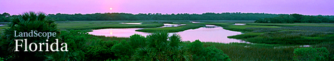
 © Steve Vaughn/Panoramic Images (Florida Title Image Large)
Florida Everglades
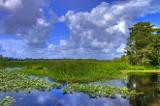
© John Anderson/Shutterstock Florida Everglades Featured Image
A prominent and unmistakable feature of south Florida, the Everglades is a large, grassy, freshwater marsh intersected by tree islands and other diverse habitats. The wetlands form one of the largest and most complex ecosystems in North America, supporting an array of wildlife that includes alligators, Florida panthers and hundreds of species of birds.
The Everglades ecosystem historically spread across roughly 4,000 square miles in central and south Florida, stretching southward from the Kissimmee Chain of Lakes to Florida Bay. This expanse of interconnected wetlands once included the four million-acre “River of Grass” known as the Everglades.
Draining projects and conversion to agricultural lands during the past 100 years has reduced the Everglades ecosystem by almost 50 percent. Since the 1930s, wading bird populations in the region have declined by more than 90 percent. Today, only the southern third of this important marshland remains relatively undisturbed.
The natural plant communities and vegetation of the Everglades remains a vital part of the larger historic ecosystem. The region is home to nearly 70 threatened or endangered animal species and the only place in the world where alligators and crocodiles occur together. The shallow, slow-moving waters also provide critical habitat for hundreds of species of fish, amphibians, birds and invertebrates.
Sawgrass (Cladium jamaicense) is the predominant marsh plant, forming extensive stands that, in wetter areas, reluctantly give way to open-water sloughs. Also scattered through the marsh are distinctive tree islands. These slightly elevated islands are elongated in the direction of water flow. Tropical hardwood trees and shrubs grow on the higher and broader upstream ends of the islands, while swampy, bay forest plants occur on the lower, narrower, downstream portions.
Towards the Everglades’ southernmost reaches, broad marl prairies flank the narrowing sawgrass marsh. These seasonally inundated prairies are important feeding areas for wading birds. The marshes and prairies, in turn, give way to mangrove swamps, a critical zone for generating microorganisms and providing shelter for larger species.
The Everglades remains a symbol of a wilder, untamed Florida despite decades of draining, development and degradation. Everglades National Park, the only subtropical preserve in North America, is now a recognized World Heritage Site, an International Biosphere Reserve and a Wetland of International Importance.
Learn more about the Everglades Ecosystem:
The Living Everglades Website - South Florida Water Management District
Description of the Everglades Ecosystem Website - Florida Department of Environmental Protection
Everglades American Treasure Website - South Florida Water Management District
The History of the Everglades
When Florida became a state in 1847, the nine million acre expanse of interconnected wetlands known as the Everglades was viewed as a major obstacle to settlement. To help the fledgling state raise money for drainage projects, the United States Congress in 1850 granted Florida 20 million acres of “overflowed lands” – more than half of the state’s total area – for sale to interested buyers.
By 1926, five major canals were carrying water from Lake Okeechobee to the Atlantic Ocean. To prevent future flooding in the area, a 34-foot levee was constructed in 1938 around the south shore of Lake Okeechobee. These attempts at draining the Everglades and controlling water flow unintentionally resulted in problems with over-drainage during dry periods. This set the stage for damaging peat fires, saltwater intrusion along the east coast and major flooding following heavy rains in 1947.
The U.S. Army Corps of Engineers attempted to correct these problems by dividing the Everglades into drained and un-drained portions. Levees in the un-drained central third, known as the Water Conservation Area, could impound water from, or release water into, the drained Everglades Agricultural Area bordering Lake Okeechobee. The southern third of the Everglades was left in its natural condition and was donated back to the Federal government, which, in turn, created Everglades National Park in 1947.
The system of canals and levees, completed by the Corps in 1963, was largely successful in terms of controlling floodwaters and recharging groundwater supplies. Yet this massive engineering project adversely affected the unique and diverse environment within the Everglades ecosystem. With water flow through Everglades National Park reduced to 70 percent of its original volume, this once healthy wetland ecosystem began showing signs of illness. Changes in water flow patterns and the timing of water releases into the Park led to unfavorable changes in Everglades vegetation, decreased biodiversity and significant declines among numerous wildlife species. Breeding bird populations were particularly hard hit, with some species declining by more than 90 percent. Furthermore, freshwater runoff re-directed through drainage canals to the Atlantic coast were disrupting offshore ecosystems, defoliating sea grasses and reducing populations of important fish species.
Today, a comprehensive plan for restoring the Everglades is guiding efforts to restore, protect, and preserve the water resources of central and southern Florida, including the Everglades. Federal and state governments are buying back critical lands for enhanced water filtration and storage. Altered water release schedules are helping restore some wetland functions that mimic pre-drainage conditions.
The Federal Water Resources Development Act of 2000 included a plan to restore as far as possible, and over the course of several decades, the natural functioning of the entire Everglades drainage system, from the headwaters of the Kissimmee River to Everglades National Park. The plan, with an estimated cost of $7.8 billion, seeks to address 60 key elements, including improved water deliveries to the Everglades and to coastal estuaries, the removal of barriers to water sheet flow and improved water conservation.
Learn more about the History of the Everglades:
Comprehensive Everglades Restoration Plan (CERP) Website
The Living Everglades Website - South Florida Water Management District
Description of the Everglades Ecosystem Website - Florida Department of Environmental Protection
Go to the Map

Use the interactive map to zoom smoothly from a national view to state and local perspectives anywhere across the country.

